METRO is a rapid transit system serving the Minneapolis – St. Paul metropolitan area. It has light rail and bus lines. Important areas like Minneapolis-St. Paul International Airport, Bloomington, Downtown Minneapolis and Downtown St. Paul are covered by this system.
Minnesota Metro
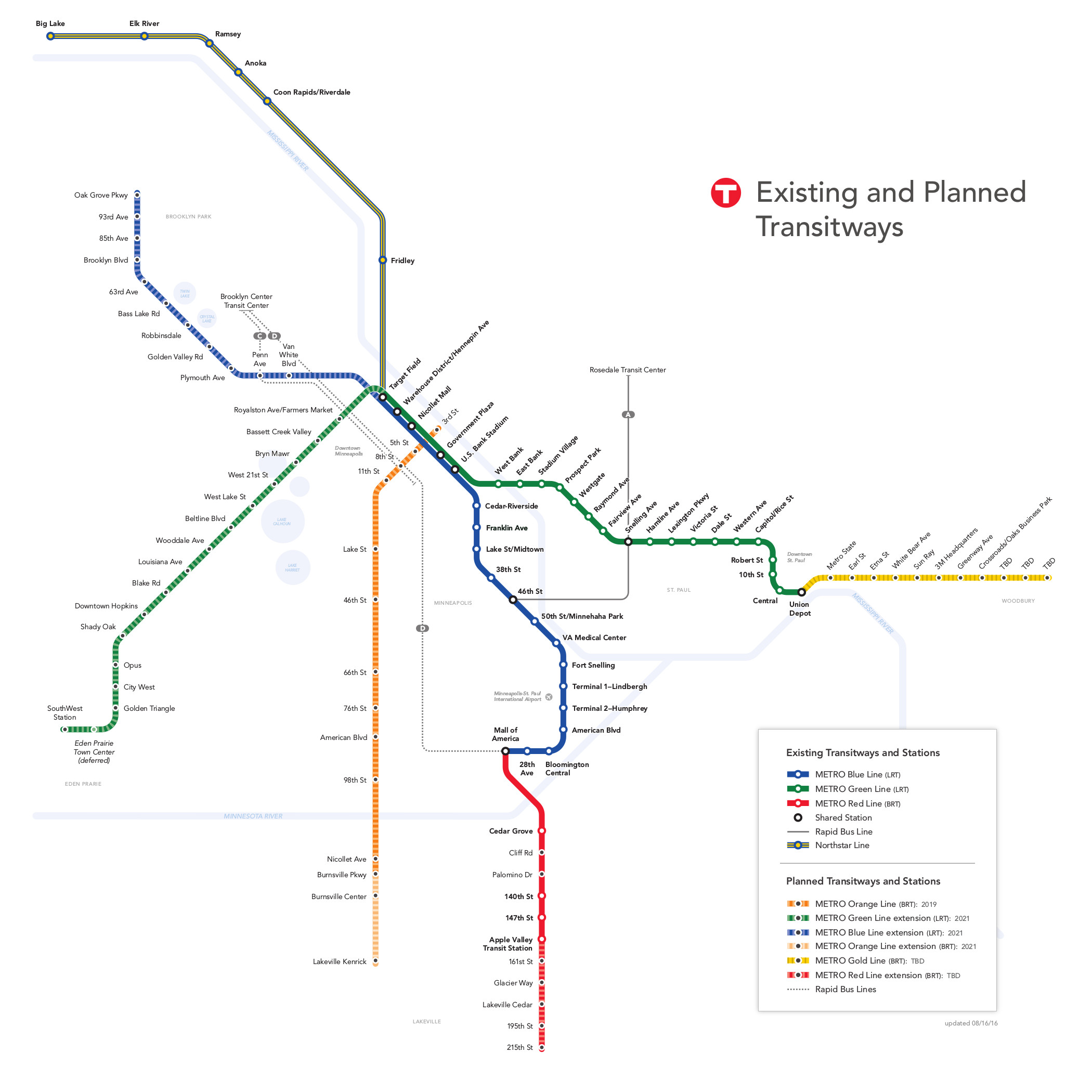
Currently, Minnesota Metro operates through 4 lines, namely, Green Line, Blue Line, A Line and Red Line. Metropolitan Council owns the system. Metro Transit operates the Green, Blue and A lines. Minnesota Valley Transit Authority is operating the Red Line. The route length of the light rail network is 35.1 km. There are total 41 stations along the complete route, though, some of which are shared by two lines.
Historical Background
In the 1970s, when San Francisco's Bay Area Rapid Transit and Washington D.C.'s Metro system were being built, the Metropolitan Council proposed for a rapid transit system in the Minneapolis – St. Paul metro area. It was really necessary to create a mass transit system to join both of the downtowns. However, the project was opposed due to political reasons.
In 1999, the project got approval from the state government and the construction of the first line, currently known as Blue Line, began. METRO system came to life on June 26, 2004. The Red Line started operation in mid-2013 and the Green Line in mid-2014. The A line is open since June 11, 2016.
Hours of Operation
Parts of the metro system, namely, the entire Green Line and two airport terminal stations on the Blue Line, operate 24/7. In the night, the rest of the Blue Line shuts down for about 3 hours. During the day time, one train comes every 10 minutes. In the nighttime and also on weekends and holidays, the time gap between two consecutive trains increases. No matter whether it is a train or bus, there is one vehicle coming every 15 minutes most of the time of the day.
- View the schedule of Blue Line trains here.
- View the schedule of Green Line trains here.
- View the schedule of Red Line buses here.
Lines and Stations
The lines are differentiated by color, not by number. The Target Field Station is currently acting as a hub station in Minneapolis. In future, Union Depot in St. Paul may also become a hub.
The train lines operate following the principle of shared and exclusive right of way. In the downtown areas, exclusive right-of-way principle is followed.
_16.jpg)
Blue Line
The route starts at Target Field and ends at American Mall, covering 19 stations. All the stations on this route are at ground level except the Lindbergh Terminal. It runs parallel to Hiawatha Avenue along an abundant land. It has a short section running inside a tunnel under Minneapolis-St. Paul International Airport. Depending on the traffic pressure, one, two or three car trains run on this line.
A number of bus lines are connected to this line and reaching workplaces, malls, restaurants and entertainment venues is never an issue. It shares 5 stations with the Green Line. The route is 12 km long and connects Twin Cities’ three important spots, namely, Downtown Minneapolis, the international Airport and Mall of America. Passengers can travel free of cost from one airport terminal to other.
At the north terminal Target Field station, a transfer is possible to the Northstar Rail Line. At the southern terminal American Mall station, passengers can change to the METRO Red Line and to other bus lines. In 2012 and 13, the reported total ridership was more than 10 million. Daily ridership on this line is counted at 31, 471. 50% of railway commuters now use this light rail line. Each train can carry maximum 186 passengers. Major park and ride lots are located at 28th Avenue and Fort Snelling stations.
The stations along the route are: Mall of America, 28th Avenue, 50th Street / Minnehaha Park, Bloomington Central, Fort Snelling, American Boulevard, Cedar-Riverside, Terminal 2 - Humphrey, Terminal 1 – Lindbergh, VA Medical Center, 46th Street, 38th Street, Lake Street / Midtown, Franklin Avenue, U.S. Bank Stadium, Nicollet Mall, Warehouse District / Hennepin Avenue, Government Plaza, Target Field
Green Line
The historic Capitol City, the excitement of Downtown Minneapolis, the culinary scenery of University Avenue and landmarks like the University of Minnesota – the Green Line connects you to all of these. It reaches Downtown St. Paul from Downtown Minneapolis in about 46 minutes. The two terminal stations are Target Field in Minneapolis and Union Depot in St. Paul.
The line enjoys an exclusive right-of-way along the University Avenue. Near Washington Avenue Transit Mall, it shares track with the bus line. The route is 18 km long and has 23 stations along it. According to 2015 record, annual ridership was 12.4 million. On average, daily 37,402 passengers travel through this line. From this line, it is easy to transfer to the Northstar Rail Line.
The stations along this line are: Union Depot, 10th Street, Capitol/Rice Street, Hamline Avenue, Western Avenue, Dale Street, Central, Victoria Street, Lexington Parkway, Stadium Village, Robert Street, Fairview Avenue, Snelling Avenue, Raymond Avenue, Westgate, Prospect Park, West Bank, U.S. Bank Stadium, Government Plaza, East Bank, Nicollet Mall, Warehouse/Hennepin Avenue
Red Line
It is a bus service between Mall of America and Apple Valley. Shopaholics frequently travel on this route. It allows easy 10 minutes connection between Mall of America and Twin Cities Premium Outlets. In addition, it covers some of the fast-growing neighborhoods in the region. From this line, passengers can transfer to the Blue Line for reaching the Downtown Minneapolis and airport. Change at US Bank Stadium station for Downtown St. Paul.
The stations have bus pull-offs making it easier for one bus to pass another while dropping or picking passengers. In 2013, the ridership was counted at 130,733. In 2014, that rose up to 2,706, 416. It covers 5 stations, namely,
- Apple Valley
- 147th Street
- 140th Street
- Cedar Grove
- Mall of America
A Line
It is a rapid bus transit serving Twin Cities. Previously, it was known as Snelling Avenue Bus Rapid Transitway. It has the same route like other Metro buses the only difference lies in the running speed. The Transit signal priority system is used in many of the traffic signals on this line. On this bus, there is no provision of buying tickets. Buy tickets before riding the bus or use your Go-To card. You can board the bus from any door.
The vehicles are more advanced than the regular METRO buses offering more space to the passengers. They are also disabled-friendly. From this line, one can transfer to Green Line and Blue Line. It covers attractions like Highland Village, Hamline University, Minnehaha Park, Harmar Mall etc. The operator is expecting a daily ride of 8000 passengers by 2030.
There are 20 stations along the route. The stations along this line are: 46th Street, 46th Street & 46th Avenue, 46th Street & Minnehaha, Ford & Woodlawn, Ford & Finn, Ford & Kenneth, Ford & Fairview, Snelling and Highland, Snelling & Randolph, Snelling & St. Clair, Snelling & Grand, Snelling & Dayton, Snelling & University, Snelling & Minnehaha, Snelling & Hewitt, Snelling & Como, Snelling & Hoyt – Nebraska, Snelling & Larpenteur, Snelling & Country Road B, Rosedale Transit Center

Expansion
The expansion program includes both creations of new lines as well as extensions of the existing ones. Some of these projects are currently at planning stage; for others, construction work has begun already.
- C Line – Once complete, this bus rapid transit line is expected to connect the Brooklyn Center Transit Center to Downtown Minneapolis. However, it is only at planning stage. Construction may begin in 2018.
- Orange Line – This rapid bus service is planned to connect Minneapolis to Bloomington, Richfield, Burnsville and Lakeville. It should start operation in 2019.
- Gold Line – This rapid bus transit is expected to connect Woodbury and St. Paul Union Depot. It is also in the planning stage.
- Blue Line – The Blue Line would be extended to Brooklyn Park. It should be completed by 2021.
- Green Line – This Line would be extended in the southwestern direction to cover multiple suburbs. The operation should begin in 2020.
- Red Line – Red Line is planned to be extended to Lakeville, Minnesota.
A lot of other proposals are waiting to be finalized.
Fare and Ticket
The cost of travel between two downtowns is $0.50. Adults fare in the rush hours is $2.25. In the non-rush hours, the price reduces by 50 cents. Seniors, disabled persons and students get discounts on the standard fare. Children up to 6 years can ride for free.
Get the details on METRO fare here.
A passenger must buy the ticket before the commencement of the journey. Tickets can either be bought from ticket vending machines on the stations or by scanning the Go-To cards at the designated points. Passengers can either buy single journey tickets or use multiple journey passes. Passes are available in many forms e.g. Day pass, Event 6-hour pass etc. For students of the University of Minnesota, the U-passes are very useful.
Get more information on the ticketing system from here.
Facilities and Services
- Most of the stations have adjacent free parking lots. However, you cannot park there overnight.
- The metro system operates a Lost and Found unit at 570 Sixth Avenue North, Minneapolis.
- Prediction of real-time departure is shown on platform electronic display boards as well as on Metro Transit’s website.
- The trains have separate racks for holding bikes.
- In Minneapolis, ticket vending machines show instructions in Spanish, English, Hmong and Somali.
- There are cameras fitted in the stations as well as on the vehicles.
- The Red Line offers free Wi-Fi connection.
Rules
- Passengers must obey the safety rules and take note of the barriers for their own safety.
- Passengers must stay behind the yellow line drawn on the platform when a train is approaching.
- For a valid ride, a passenger must carry his/her ticket with him throughout the journey.
- Tickets remain valid up to 2.5 hours after purchase. This includes transfers also.
Tips
- If you’re a victim or witness of a criminal activity in the station or on the trains, call immediately the Metro Transit Police.
- Transfer from Minnesota metro system to Northstar trains requires additional payment. Make sure you have bought the right tickets before you make such transfer.