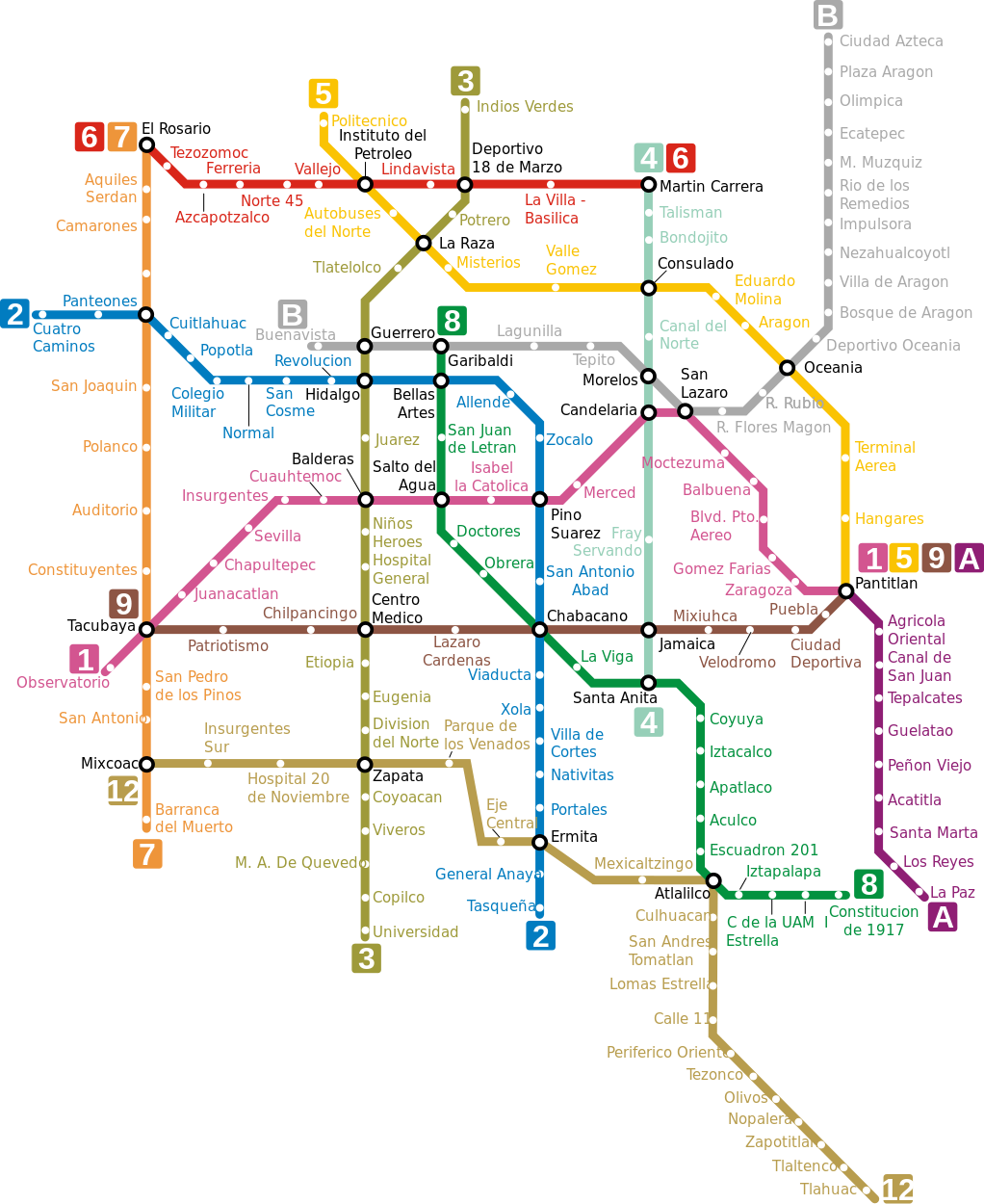
The Mexico City Metro, operated by the Sistema de Transporte Colectivo (STC), has 12 lines and 195 stations covering approximately 226 km of track. It operates Monday to Friday from 5:00 to 00:00, Saturdays from 6:00 to 00:00, and Sundays and public holidays from 7:00 to 00:00. A single ticket costs 5 pesos; senior citizens, people with disabilities and children under 5 travel free. It is the largest metro network in Latin America and one of the ten most used in the world.
Mexico City Metro
The Mexico City Metro, inaugurated on 4 September 1969, is not simply the largest urban rail network in Latin America. In many respects it is a cross-section of the Mexican capital itself: immense, culturally unique, socially indispensable and far more complex than most visitors imagine before arriving.
Managed by the Sistema de Transporte Colectivo (STC), the network spans approximately 226 km of double track with 12 lines and 195 stations serving both Mexico City and several municipalities of the State of Mexico. On a normal day it moves more than 4 million people. At its historical peak, in 2011, it carried over 7.5 million passengers in a single day — a figure only a handful of metro systems in the world have ever matched.
For residents, the Metro is not a complementary option: it is the backbone of millions of daily journeys in a metropolis where distances are enormous, traffic can paralyse major avenues for hours, and the car is beyond reach for many. For the foreign visitor it can seem intimidating at first. In practice, it is the fastest, cheapest and most authentic way to cross the capital.
Key system data
| Official name | Sistema de Transporte Colectivo Metro (STC Metro) |
|---|---|
| Operator | STC — Government of Mexico City |
| Opened | 4 September 1969 (Line 1) |
| Type | Heavy urban metro (pneumatic and conventional) |
| Lines | 12 (1, 2, 3, 4, 5, 6, 7, 8, 9, A, B, 12) |
| Stations | 195 |
| Network length | Approximately 226 km |
| Passengers | Over 4 million daily (historical peak: 7.5 million) |
| Mon–Fri hours | 05:00 – 00:00 |
| Saturday hours | 06:00 – 00:00 |
| Sun & holidays | 07:00 – 00:00 |
| Single ticket fare | 5 pesos (since 2013) |
| Payment | Single ticket or Tarjeta de Movilidad Integrada (MI Card) |
| Integration | Metrobús, Cablebús, Light Rail, RTP, trolleybuses |
| Official website | metro.cdmx.gob.mx |
Why the Mexico City Metro is unique
Many metros matter to their city. The Mexico City Metro, however, is a genuine urban survival infrastructure. The Mexican capital grew explosively for decades, creating a colossal metropolis where millions of people need to cover enormous distances every day. Without the Metro, the city would collapse even more under private car dependency.
Unlike many European metros or those in smaller cities, this system has a predominantly social and occupational function. The passenger density, the intensity of peak hours and the relationship with outlying municipalities have no parallel in the region. But what makes this metro truly unique goes beyond its size.
Every station has its own visual icon, recognisable at a glance. This pictogram system was created in 1969 to help users with limited literacy navigate the network. Today it is a fundamental part of the Metro's identity and one of the most original wayfinding systems in the world. Some stations incorporate murals, archaeological remains and permanent exhibitions that turn the commute into something more than a simple journey. Few networks anywhere are as culturally distinctive.
History of the Mexico City Metro
During the 1950s and 1960s, Mexico City grew at breakneck speed. Urban expansion completely overwhelmed the existing mobility model. Buses were insufficient and traffic was beginning to strangle a city spreading far beyond its historic core. In that urgent context, the idea of a major modern metropolitan system was born.
Line 1 was inaugurated in September 1969, initially connecting Zaragoza with Chapultepec. That first stretch marked the beginning of a gigantic urban transformation. The French influence was decisive in the original technical design: several lines use rubber-tyred trains, inspired by technology developed in Paris, allowing better acceleration, shorter braking distances and quieter operation in curves.
The 1985 earthquake left a deep mark on the capital's urban infrastructure. Since then, structural safety and maintenance have had a particularly sensitive dimension: Mexico City is built on the sediments of an ancient lake, which creates unique geotechnical challenges found nowhere else in the world.
The most controversial chapter in the system's modern history was Line 12. Conceived as a major expansion towards the southeast, it accumulated technical problems, partial closures and political controversy. On 3 May 2021, a section of elevated viaduct collapsed near Olivos station, causing 26 deaths. The incident completely changed public perception of safety, maintenance and technical oversight. Expert reports from Norwegian firm DNV and official documentation are available on the transparency portal created by the CDMX government.
Mexico City Metro lines
The network has 12 lines, each identified by a number or letter and a colour. More than 50% of stations are underground (approximately 115); around 44 are at surface level and some 67 operate on elevated viaduct. The combination of rubber-tyred and conventional trains, old and modern lines, elevated and underground sections, gives the system a technically varied character.
Line 1: Pantitlán – Observatorio (pink)
The oldest line on the network. Nearly 19 km long, it runs east to west through the heart of the city centre. 20 stations, 19 of them underground. It serves key areas including Chapultepec, Insurgentes and the Historic Centre. Recent renovations have been extensive precisely because of the enormous passenger flow this line carries.
Stations: Observatorio, Tacubaya, Juanacatlán, Chapultepec, Sevilla, Insurgentes, Cuauhtémoc, Balderas, Salto de Agua, Isabel la Católica, Pino Suárez, Merced, Candelaria, San Lázaro, Moctezuma, Balbuena, Boulevard Puerto Aéreo, Gómez Farías, Zaragoza, Pantitlán.
Pantitlán, the eastern terminal, is probably the most intense transport hub in all of Latin America. If you have never seen rush-hour crowds in a megacity metro, this video gives a sense of the real scale:
Line 2: Cuatro Caminos – Tasqueña (blue)
23 km running north to south through the historic centre. One of the most useful lines for visitors: it connects the Historic Centre (Zócalo, Bellas Artes), traditional southern neighbourhoods and the Cuatro Caminos interchange to the north. 24 stations, inaugurated August 1970.
Stations: Cuatro Caminos, Panteones, Tacuba, Cuitláhuac, Popotla, Colegio Militar, Normal, San Cosme, Revolución, Hidalgo, Bellas Artes, Allende, Zócalo, Pino Suárez, San Antonio Abad, Chabacano, Viaducto, Xola, Villa de Cortés, Nativitas, Portales, Ermita, General Anaya, Tasqueña.
Line 3: Indios Verdes – Universidad (olive green)
23 km north to south, critically important for commuters and students. Connects Indios Verdes (major northern hub), the city centre (Hidalgo, Juárez) and the university district, with UNAM as the southern terminus. 21 stations, 17 underground.
Stations: Indios Verdes, Deportivo 18 de Marzo, Potrero, La Raza, Tlatelolco, Guerrero, Hidalgo, Juárez, Balderas, Niños Héroes, Hospital General, Centro Médico, Etiopía / Plaza de la Transparencia, Eugenia, División del Norte, Zapata, Coyoacán, Viveros / Derechos Humanos, Miguel Ángel de Quevedo, Copilco, Universidad.
Line 4: Santa Anita – Martín Carrera (cyan)
10 km, 10 stations. Functions primarily as a connector in the eastern part of the city. 8 stations on elevated viaduct, 2 at surface level. Heavily used by local commuters, less relevant for tourists.
Stations: Martín Carrera, Talismán, Bondojito, Consulado, Canal del Norte, Morelos, Candelaria, Fray Servando, Jamaica, Santa Anita.
Line 5: Politécnico – Pantitlán (yellow)
15 km, 13 stations. Crucial because it includes Terminal Aérea station, connecting to the international airport. 9 stations at surface level, 4 underground. Important for northern commuters and airport passengers.
Stations: Pantitlán, Hangares, Terminal Aérea, Oceanía, Aragón, Eduardo Molina, Consulado, Valle Gómez, Misterios, La Raza, Autobuses del Norte, Instituto del Petróleo, Politécnico.
Line 6: El Rosario – Martín Carrera (red)
13 km, 11 stations. Crosses the northern part of the city. 10 stations underground, 1 at surface. Provides access to El Rosario, one of the network's major interchanges.
Stations: El Rosario, Tezozomoc, Azcapotzalco, Ferrería, Norte 45, Vallejo, Instituto del Petróleo, Lindavista, Deportivo 18 de Marzo, La Villa-Basílica, Martín Carrera.
Line 7: El Rosario – Barranca del Muerto (orange)
18 km, 14 stations. One of the most interesting lines for international visitors: serves Polanco, the National Auditorium and Chapultepec. 13 stations underground, linking the north with the west of the city.
Stations: El Rosario, Aquiles Serdán, Camarones, Refinería, Tacuba, San Joaquín, Polanco, Auditorio, Constituyentes, Tacubaya, San Pedro de los Pinos, Mixcoac, Barranca del Muerto.
Line 8: Garibaldi – Constitución de 1917 (green)
20 km, 19 stations. Connects the centre (Garibaldi, Bellas Artes) with working-class neighbourhoods and the eastern city. 14 stations underground, 5 at surface.
Stations: Garibaldi, Bellas Artes, San Juan de Letrán, Salto del Agua, Doctores, Obrera, Chabacano, La Viga, Santa Anita, Coyuya, Iztacalco, Apatlaco, Aculco, Escuadrón 201, Atlalilco, Iztapalapa, Cerro de la Estrella, UAM-I, Constitución de 1917.
Line 9: Pantitlán – Tacubaya (dark brown)
15 km, 12 stations. Acts as a strategic east-west link between densely populated zones. 8 stations underground, 4 elevated.
Stations: Tacubaya, Patriotismo, Chilpancingo, Centro Médico, Lázaro Cárdenas, Chabacano, Jamaica, Mixiuhca, Velódromo, Ciudad Deportiva, Puebla, Pantitlán.
Line A: Pantitlán – La Paz (purple)
17 km, 10 stations. The only line that leaves Mexico City proper to serve municipalities in the State of Mexico to the east. Just 1 underground station, 9 at surface level. Note: the single ticket does not cover onward transfer on Line A — a new fare must be paid.
Stations: Pantitlán, Agrícola Oriental, Canal de San Juan, Tepalcates, Guelatao, Peñón Viejo, Acatitla, Santa Marta, Los Reyes, La Paz.
Line B: Ciudad Azteca – Buenavista (green and grey)
23 km, 21 stations. Also extends into the State of Mexico at its northern terminus. Serves populous eastern areas and connects with the centre at Buenavista (Ferrocarriles Suburbanos). 6 stations underground, 11 at surface, 4 elevated.
Stations: Ciudad Azteca, Plaza Aragón, Olímpica, Ecatepec, Múzquiz, Río de los Remedios, Impulsora, Nezahualcóyotl, Villa de Aragón, Bosque de Aragón, Deportivo Oceanía, Oceanía, Romero Rubio, Ricardo Flores Magón, San Lázaro, Morelos, Tepito, Lagunilla, Garibaldi, Guerrero, Buenavista.
Line 12: Tláhuac – Mixcoac (gold)
25 km, 20 stations. The most modern line in the network, combining elevated and underground sections. Designed to connect the southeast with the southwest of the city. Following the viaduct collapse in 2021 and subsequent rehabilitation, it operates again with restrictions on certain stretches.
Stations: Tláhuac, Tlaltenco, Zapotitlán, Nopalera, Olivos, Tezonco, Periférico Oriente, Calle 11, Lomas Estrella, San Andrés Tomatlán, Culhuacán, Atlalilco, Mexicaltzingo, Eje Central, Parque de los Venados, Hospital 20 de Noviembre, Insurgentes Sur, Mixcoac.
Key stations of the Mexico City Metro
Pantitlán — the mega-interchange
Pantitlán is not simply a station. It is one of the largest transport hubs in all of Latin America, where Lines 1, 5, 9 and A converge. During rush hour the pedestrian flow is so dense it is hard to imagine anything comparable without having been there. Transfers can be lengthy — follow the signs and stay with the main flow of passengers.
Hidalgo — gateway to the historic centre
One of the most useful stations for visitors. Connects Lines 2 and 3 and gives comfortable access to Alameda Central, the Palacio de Bellas Artes, Paseo de la Reforma and the Historic Centre.
Pino Suárez — the archaeological station
Famous for harbouring the remains of an Aztec temple within the station concourse itself. Workers building the station in the 1970s discovered a circular pre-Hispanic structure dedicated to Ehécatl, the wind god. It is protected behind glass and visible from the platform. Few metro stations in the world integrate modern infrastructure and real archaeological heritage this visibly.
Bellas Artes — the tourist hub
Probably the station most recognised by visitors. Direct access to the Palacio de Bellas Artes, Torre Latinoamericana, Alameda Central and the heart of the Historic Centre. Connects Lines 2 and 8. Can be very crowded at weekends or during events.
Chapultepec — for the park and museums
Gateway to Bosque de Chapultepec, the Museo Nacional de Antropología, Museo Tamayo and the Reforma corridor. Line 1 runs directly below Paseo de la Reforma at this point.
Universidad — the UNAM campus
Southern terminus of Line 3. The UNAM campus is enormous — a city within the city. Many visitors underestimate the internal distances. Check a campus map before heading to a specific building or museum.
Getting to the airport by Metro
Line 5 connects the city centre with Terminal Aérea station, which gives access to Terminal 1 of Benito Juárez International Airport (AICM). It is by far the cheapest option. However, there are practical factors to consider:
- Terminal Aérea only serves Terminal 1; a free internal airport bus connects to Terminal 2.
- Moving large luggage on the Metro during peak hours is very uncomfortable, especially at transfer stations.
- If you are travelling light, the Metro saves money and avoids the chaotic airport access traffic.
- If you have several suitcases, arrive tired or travel at night, an authorised taxi or Uber is more practical.
- The Felipe Ángeles International Airport (NAIFA) to the north has no Metro connection — use the Aerobus or Suburban Train instead.
Fares, tickets and the Tarjeta de Movilidad Integrada
The Mexico City Metro is extraordinarily cheap compared with any major international city. The single ticket (boleto unitario) costs 5 pesos (price in force since 2013) and covers a complete journey with transfers to other lines at no extra charge. Exception: Line A requires a new fare to be paid.
Free travel for:
- Senior citizens
- People with disabilities
- Children under 5 years old
- Young people enrolled in INJUVE programmes
- On-duty police officers
The Tarjeta de Movilidad Integrada (MI Card) is the recommended payment method. It is a rechargeable smart card that provides access not only to the Metro but also to Metrobús, Cablebús, trolleybuses and other modes in the CDMX network. It reduces the need for cash, speeds up turnstile access and is particularly practical if you use several transport modes during your stay. It can be topped up at station ticket offices and authorised points throughout the city.
Bicycles are permitted on weekends and public holidays. A student card provides a reduced fare of 3 pesos per journey for eligible beneficiaries.
Safety on the Mexico City Metro
The vast majority of journeys pass without incident. The Metro is broadly safe, and millions of people use it every day without problems. That said, it is worth being realistic: this is an extremely crowded system, and the most common issues are pickpocketing and carelessness with bags or mobile phones, particularly on packed trains and at congested stations.
- Keep your bag or backpack in front of you during peak hours.
- Avoid using your phone visibly on busy platforms.
- Several stations and trains have carriages reserved exclusively for women and children, especially during rush hours. Floor markings and door signs make this clear.
- If you can avoid peak hours (07:00–09:30 and 18:00–20:30 on weekdays), the experience is radically different.
- Mexico City has real seismic risk. All stations display clear instructions on what to do in case of an earthquake during service.
Art, architecture and culture on the Metro
The Mexico City Metro has a cultural dimension far beyond most comparable systems. Several stations incorporate historical murals, permanent exhibitions, artistic installations and archaeological pieces integrated into the architecture. Pino Suárez houses a pre-Hispanic temple. La Raza features the Science Tunnel, a walkway with illustrated panels on history and biology.
The Museo del Metro (Metro Museum), at Mixcoac station (Lines 12 and 7), is dedicated to the history of the system. It covers the evolution of transport in the city, displays historical rolling stock, models and archive photographs. It is free of charge and highly recommended for anyone who wants to understand how the Metro was built and expanded over more than five decades.
The station icon system is perhaps the Metro's most culturally recognised feature. Each station has its own distinctive logo, designed in 1969 to help users with limited literacy navigate the network. Today those icons are part of Mexico's collective visual identity.
Multimodal integration
| System | Description | Fare integration |
|---|---|---|
| Metrobús | Bus rapid transit on dedicated lanes. On several corridors it is more practical than the Metro. | Yes, with MI Card |
| Cablebús | Urban cable car. Connects elevated northern and eastern areas that are otherwise hard to reach. | Yes, with MI Card |
| Light Rail (Tren Ligero) | Serves the southern city (Tasqueña–Embarcadero), complementing Line 2. | Yes, with MI Card |
| Trolleybuses | Electric bus network on several major avenues. | Yes, with MI Card |
| RTP | Public bus network covering routes where the Metro does not reach. | Yes, with MI Card |
| Suburban Train | Regional rail from Buenavista northward (Cuautitlán). Useful for NAIFA airport. | Separate fare |
What the Metro does NOT cover well
One of the most useful facts that rarely appears in tourist guides. The Metro is enormous, but there are important areas it does not cover well or at all:
- Santa Fe: major business and shopping district to the west, with no direct rail connection. Reach it by combining Metro with a bus or using Uber.
- Central Polanco and Lomas de Chapultepec: Line 7 serves the edge of Polanco (Polanco station), but much of the neighbourhood and Lomas are a significant distance from any station.
- Felipe Ángeles International Airport (NAIFA): no Metro connection. Requires Suburban Train plus bus, or private transport.
- Peripheral State of Mexico areas: although Lines B and A extend into neighbouring municipalities, large sections of the metropolitan area remain outside the network.
- Late night: the Metro does not run between midnight and 05:00. At those hours only taxis and ride-hailing apps are available.
Hours and frequencies
| Day | Opens | Closes |
|---|---|---|
| Monday to Friday | 05:00 | 00:00 |
| Saturday | 06:00 | 00:00 |
| Sunday & public holidays | 07:00 | 00:00 |
Frequencies vary by line, time of day and day of week. On main lines during peak hours, trains run every 2–4 minutes. During off-peak hours or on secondary lines, intervals can reach 6–10 minutes. Saturday evenings and Sunday afternoons see noticeably reduced frequencies on several lines.
Practical tips for visitors
- Get the MI Card on your first day if you plan to use Metrobús or Cablebús as well. It saves time and money.
- Avoid peak hours (07:00–09:30 and 18:00–20:30 on weekdays) if you have flexibility. The difference in crowding is enormous.
- For the Historic Centre, the most useful stations are Zócalo, Bellas Artes, Hidalgo and Isabel la Católica (Line 1).
- For Chapultepec and the museums: Chapultepec station (Line 1) or Auditorio (Line 7).
- For Terminal 1 of the airport: Terminal Aérea station (Line 5), with transfer at Pantitlán or direct depending on your starting point.
- Carriages reserved for women and children are marked on the floor and doors. During rush hours these designations are enforced.
- Carry some cash for a ticket if you do not have an MI Card. Ticket machines work but can have queues.
- The Metro map can give a misleading impression of distances. Mexico City is vast: two stations close on the map can mean a long walk at street level.
- Bicycles are allowed at weekends and on public holidays, not during peak hours on working days.
- Download the official Metro app or use Google Maps to plan journeys with transfers.
Curiosities about the Mexico City Metro
- The ticket price has been one of the lowest in the world for decades. Despite this, the fare has been raised 11 times since 1969. The increase to 5 pesos in 2013 was approved following a user survey.
- In 2014, the least-used station was Tlaltenco (Line 12) with 150,000 passengers, while Indios Verdes recorded 44 million entries in the same year.
- Several lines use rubber-tyred trains, technology inspired by the Paris Métro, allowing smoother cornering and shorter stopping distances.
- The Mexico City Metro is one of the ten most heavily used metro systems in the world.
- Mexico has a significant earthquake risk. All Metro stations display clear protocols on what to do during a seismic event.
- The station icon system, created in 1969, was originally designed to guide users with limited literacy. Today it is one of the most recognisable design systems in Mexican public life.
Frequently asked questions about the Mexico City Metro
Is the Mexico City Metro safe?
Generally, yes. The vast majority of trips pass without incident. The most common risks are pickpocketing in crowded areas during rush hours. With basic precautions — bag in front, phone stowed away, awareness of your surroundings — the Metro is perfectly usable for tourists at most times and on most routes.
Is the Metro useful for tourists?
Very useful, especially for the Historic Centre, Bellas Artes, Chapultepec, Coyoacán, the Reforma corridor and long journeys to avoid traffic. It does not cover some modern areas well, such as Santa Fe or parts of Polanco, where Uber is more practical.
How much does the Mexico City Metro cost?
The single ticket costs 5 pesos since 2013. The MI Card charges the same fare. Senior citizens, people with disabilities and children under 5 travel free.
How do I get to the airport by Metro?
Line 5 reaches Terminal Aérea station, which connects to Terminal 1 of Benito Juárez International Airport (AICM). It is the cheapest option but not ideal with heavy luggage during rush hours. For Terminal 2, take the airport's free internal shuttle from Terminal 1.
Does the Metro run all night?
No. Service ends at midnight every day. It reopens at 05:00 on weekdays, 06:00 on Saturdays, and 07:00 on Sundays and public holidays. Taxis and ride-hailing apps are the alternative during late-night hours.
Which lines are most useful for tourists?
Lines 1, 2 and 7 cover most tourist destinations: Historic Centre, Bellas Artes, Zócalo, Chapultepec, Polanco and the Auditorium. Line 3 is useful for UNAM and the south. Line 5 serves the airport.
What is the Tarjeta de Movilidad Integrada?
It is the official smart transit card for Mexico City's transport network. It allows access to the Metro, Metrobús, Cablebús, trolleybuses and other modes on the same rechargeable card. It replaced the older TDF and rechargeable cards. Top it up at station ticket offices and authorised points around the city.
Update history
- May 2026 — Full article update: history, key stations, airport, MI Card, safety, art, multimodal integration and expanded FAQs
- October 2024 — Network data revision and line image update
- November 2016 — General content revision
Images under the Open Government Licence of Mexico City, Creative Commons Attribution-Share Alike 4.0 International: https://www.cdmx.gob.mx/lgacdmx