The Kiev Metro is an underground public transport system located in the capital city of Ukraine: Kiev. It was inaugurated in 1960, when the country was still part of the Soviet Union. Because of this, the metro has an easily identified soviet style.
It has a system length of about 69.65 km, and has three operative lines that provide service to different areas of the city. There are 52 stations in the system. It is operated by the local government, and has the deepest metro station in the world. The corporative logo has a particular color combination: yellow and green, with a large M on the top. Basic pricing starts at 5 Ukrainian hryvnia (about $0.19 USD). The trains have different schedules, but run from about 5:30 a.m. to midnight.
Metros in Ukraine: Kiev
Kiev is the capital of the Ukrainian Republic, a country that obtained its independence in 1991, with the dissolution of the Soviet Union. It is the largest city in the country and of the state (oblast) of Kiev, with a population of about 2.8 million people.
As it a very important city in the country, Kiev concentrates many of Ukraine’s industrial and technological hubs. It also counts with many important historical landmarks that reflect its history and ideology. Along its existence, Kiev has been one of the most important cities in Eastern Europe, and a vital point for commerce in and out of Europe since the 5th century.
Later on, Kiev was a key element in the Soviet Union, as it was one of the most relevant cities on many fronts. On another hand, the city is host to many orthodox Christian institutions, and has many famous buildings related to them, like the Kiev Monastery of the Caves.
The architecture of the city varies greatly, as it has buildings from many eras of its history. However, the most numerous and easily recognizable heritage is the Soviet one. Kiev has deeply embraced sustainability and has weaved it into its development plans. It is one of Europe’s 30 Green Cities. The city is divided into two by the river Dnieper, that runs on a north-to-south route. Its climate is humid continental with an average of 23 °C in the warmer months and an average of -2 °C in winter.
The metro
The Metro of Kiev, known as the metropolitan, is the public transport by excellence in Kiev. It is also the most important system in the entire country, as well as the first to be constructed (3rd in the Soviet Union, after Moscow and St. Petersburg).
The Metro was inaugurated the 6th of November of 1960, and had only 5 stations. Currently, the system has 52 stations distributed along 3 lines that run for about 69.65 km, with a few already under construction and more on planning stages. As of 2014, there were 814 operative wagons in the system, with a total of 150 trains.
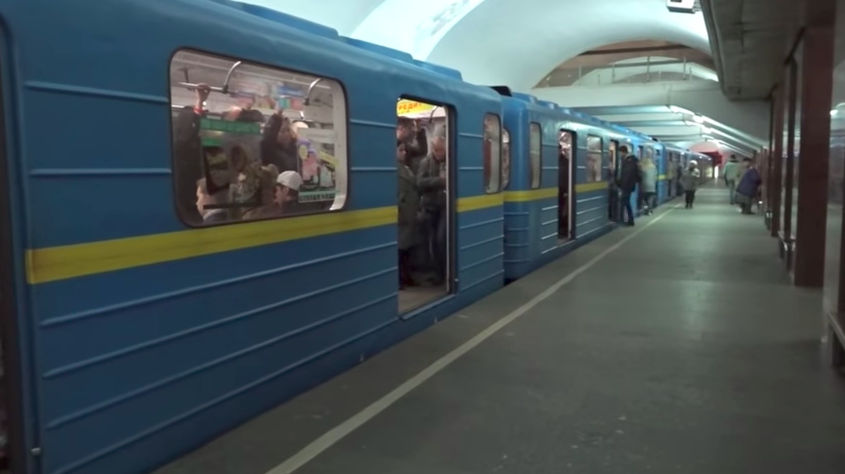
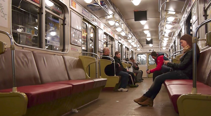
All but one train have 5 wagons. The original rolling stock was comprised of 81-717 and 81-714 models, provided by the Russian Metrovagonmash. However, new Ukrainian-built trains were introduced for line 3 in 2009. By 2016, the total ridership was close to 484.56 million. The operator is Kyivskyi Metropoliten, a company that is owned by the local government.
- Known as: Metro (metropolitan)
- System length: 69.65 km
- Track gauge: 1520 mm
- Number of lines: 3
- Number of stations: 52
- Website: www.metro.kyiv.ua
- Operated by: Kyivskyi Metropoliten
- Daily ridership: about 1.32 million people
- Inaugurated: November 6th, 1960
Brief history
The Metro of Kiev has a very long history, and dates back to 1884, when the first plans for an underground transport system were laid out. There were many other projects and modifications to existing plans along the following decades, but it was not until the 1930’s that the plans were considered seriously, when an academic study proved that the system was indeed a potential solution to the city’s transport problems. The plan was then set into motion, but construction never started because World War II broke out. In 1944, the Soviet regime ordered studies and developed the final masterplan that would be used for the construction and expansion of the metro. Construction finally began in 1949, but the city’s difficult landscape made progress slow. Some tunnels were actually carved with the help of subterranean mines.
In November 6th, 1960, the system was inaugurated, but only had 5 stations along a 5.2 km route, connecting Vokzalna with Dnepr. Another 2 stations originally meant to be opened on that date, ended up being inaugurated in 1963. Construction on the second line of the system commenced in 1971, and the first phase was opened to the public in 1976. The third line was developed a bit later, and construction started in the 1980’s, connecting the central part of the city with some sectors to the southeast; it was later expanded to the northwest.
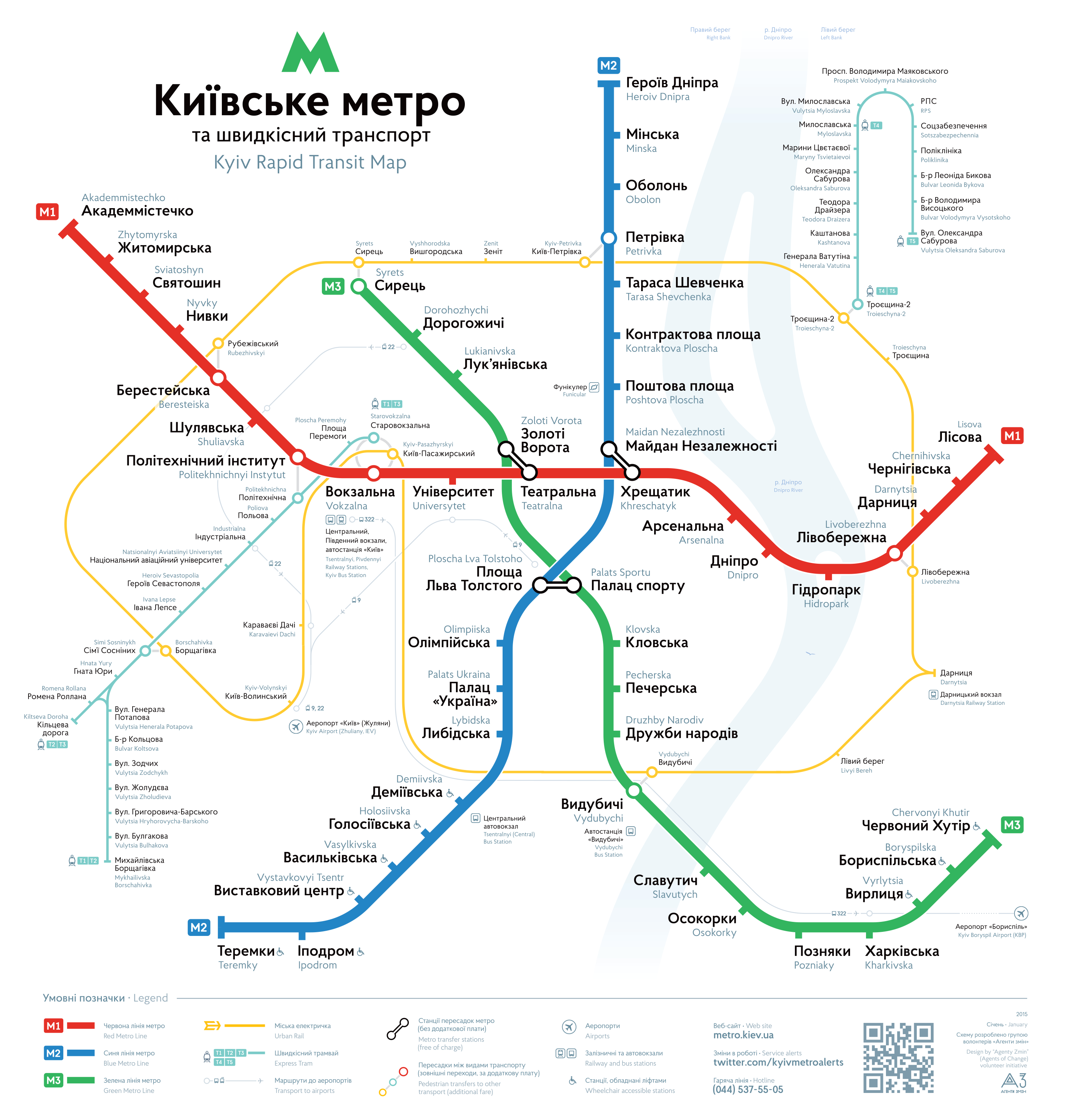
Lines and stations
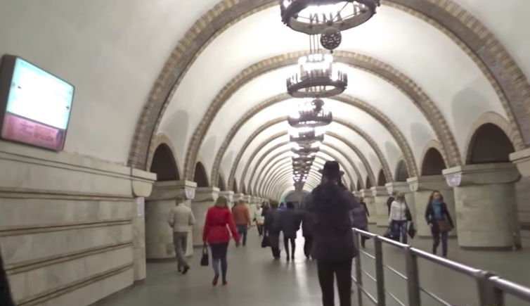
The Metro of Kiev is a subterranean train system that runs beneath the capital city of Ukraine. It has three lines that interconnect many places in the city. The system has 52 stations, most of which are also underground (20 deep stations, 6 normal subterranean, 20 sub-superficial, 4 stations at ground level and 2 elevated stations).
Line 1
The first line in the system, also known as Sviatoshynsko-Brovarska, is identified with the color red. In its first phase, it initially had only 5 stations along a 5-km route. Today, it is over 22 km in length and has 18 stations (it is tied with line 2 for the most stations on a line). The last expansion on this line was finished in 2003. It runs from east to west; its terminals are Akademmistechko to the west and Lisova to the east. A trip along the entire length of this line takes about 38 and a half minutes.
Line 2
Chronologically, this was the second line to be constructed. It is also known as Kurenivsko-Chervonoarmiyska, and runs along a north-south route in the western bank of the Dnieper river. It was a very short line when it was inaugurated in 1976. It has then received several expansions, the last one of which was completed in 2013. Currently, the line has a total of 18 stations distributed along a 20.95 km route. Its terminal stations are Heroiv Dnipra to the north and Teremky to the south. This line is identified by the color blue.
Line 3
It is the newest addition to the Metro of Kiev. This line was inaugurated on December of 1989. It is also known as Syretsko-Pecherska, and is identified by the color green. Although it is the most recent line of the system, some newer extensions have made it the longest at 23.9 km. To this date, it has 16 operative stations, and a trip from one side to the other takes about 40 minutes. This line runs along a northwest to southeast route, but planned extensions will have it run to the northeastern part of the city. The last expansion on this line was finished in 2008. Its terminal stations are Syrets and Chervony Khutir.
Connections with other systems
Even though the metro in Kiev is used by a very large number of people, a city of this size simply cannot be encompassed by a single public transport. With every new extension to the system, the metro consolidates its position as the public transport by excellence, but many people rely on other forms of transport in order to get by their daily commutes. The metro operator is Kyivskyi Metropoliten, but there is another government-owned company that runs all surface transports, a company called Kyivpastrans.
Probably, the second most important system in the city is the tram network. The history of trams in Kiev is even longer than the metro’s, as the first tram in the city was inaugurated back in the Russian Empire, in 1892. The network is not as large as it once was, but there are still several lines that pass through the city center. There are 23 lines in the network, with a total system length of 230.2 km. There are also trolleybuses operating in the city. As they are an emission-free public transport, this system is being expanded. Their presence in the city dates back to 1935, and they now have an extensive network with a system length of 499.7 km.
Naturally, there are many bus lines operating in Kiev. 80 lines provide service to the entire city with several bus types. Most metro stations are connected with the bus network, and they form an integrated public transport. Kiev, as it has a peculiar and difficult landscape, is also home to a rather unusual public transport: a funicular. It was opened to the public in 1905, and connects the modern city with the historical center of Kiev that lies on top of a hill.
The most recent addition to the public transport offering in the city is the electric train. With just one line and a system length of 50.8 km, the train runs along a circular path on the outskirts of Kiev, connecting its suburbs. It is operated by Ukrzaliznytsya State Enterprise. For long-distance travel, Kiev has several railroad stations. The most important of these is the Kiev-Pasazhyrskyi Railway station. It is the most important station in the country, and is served directly by line 1 of the metro, at Vokzalna station. Other secondary railway stations are located in the suburbs. Last but not least: a tourist favorite. Kiev also has a river tram, flowing along the Dnieper river. It serves 5 stations along 2 different routes.
Connections to the airports
The city of Kiev has two nearby airports. The largest and most important of those is the Boryspil International Airport, which is located about 29 km to the southeast of Kiev, and very close to the neighboring city of Boryspil. It is the most important airport in Ukraine, and it handles most of the air traffic and routes that pass through the country. There is no direct connection to the metro system. To reach Kiev from this airport, passengers must use other forms of transport, such as line 322 of SkyBus, a shuttle line that connects the airport to the railway station to the south of Kiev and to Kharkivska station of line 3 of the metro. Boryspilska station of line 3 is located about 18 km from the airport.
The other airport is smaller in scale, and is used mostly by domestic and government flights. The Kiev International Airport (Zhuliany) is located about 7 km to the southwest of the city, in the Zhuliany neighborhood. As it is closer to the capital, it is more connected than the Boryspil airport, although there is no direct connection with the metro. Trolleybus line 22 connects it with line 3 of the metro, at Dorohozhychi station. Bus line 78 also provides service to this airport, connecting it with Vasylkivska station of metro line 2. There are plans to directly connect this airport to the metro system through a future extension of line 4.
Schedule and timetables
El horario del Metro de Kiev varía según la estación y la línea de la que se trate. Sin embargo, en líneas generales la mayoría de las estaciones abren en torno a las cinco y media de la mañana, cerrando pasadas la medianoche.
The schedule of the Metro in Kiev varies depending on the station and line. However, it can be said that most stations commence their operations at about 5:30 a.m. and close past midnight. In line 1 (Sviatoshynsko-Brovarska), the first station to open its gates is Lisova: it opens at 5:27 a.m. On the other hand, the last station to close is Teatralna, which does so at 12:18 at night. The frequency of the trains in this line is quite high, at about 1 minute and 45 seconds between each train during peak hours, and about 3 to 4 minutes when demand is low.
For line 2, Kurenivsko-Chervonoarmiyska, it is Heroiv Dnipra station that opens first, doing so at 5:22 a.m. At night, the last station to close is called Ploshcha Lva Tolstoho, as it stops service at 12:16 a.m. During rush hours, the trains at line 2 have a frequency of about 2 minutes, but that time increases to up to 5 minutes between each train when demand for transport is low. On weekends, the trains run every 4 to 5 minutes during the entire day.
Lastly, line 3 (Syretsko-Pecherska) commences operations at 5:20 a.m. on Boryspilska station, while the last trains arrive at Vydubychi station at 12:17 at night. This is the line with the lowest frequency of the system, as trains run every 2 to 3 minutes during peak hours, but the rest of the day, the wait goes up to about 5 minutes. During weekends, this increases a bit, so passengers may have to wait for about 6 minutes or more for the next train to arrive.
Tariffs, tickets and cards
There are 4 main ways to pay the fee for the metro. The most basic one is with a token that allows the user to travel one time, without a distance limit. This token costs ₴5.00 (about $0.19 USD) since July 2017. The tokens can be acquired at any station of the system, and must be placed in the turnstiles at the entrances.
People who use the metro frequently may prefer other options of payment, as there are several alternatives. Most of them are travel cards that are valid for multiple transport systems. The first one is an electronic contactless card that can be purchased at any station for a refundable fee of ₴12.00 (about $0.45 USD). This card can be loaded with up to 50 tickets, and is rechargeable. The tickets have a slight gradual discount depending on the amount bought. If the user buys 11 to 20 trips, the cost per trip will be ₴4.90 (about $0.18 USD). Between 21 and 30 tickets, each one will cost ₴4.80 (about $0.18 USD), while buying anywhere from 31 to 50 will reduce the price of each ticket to ₴4.50 (about $0.17 USD).
Another option users have are unlimited travel cards. These cards are valid for a limited amount of time. They cost ₴380.00 (about $14.15 USD) and enable the user to travel as many times as needed for a month or for two weeks. There is a similar option that allows the user to travel for a limited amount of times (62 or 46 rides per month) and has a price of ₴3.87 (about $0.14 USD) or ₴4.13 (about $0.15 USD), respectively. These tariffs also apply to the half-month options.
The last alternative is to pay directly with a debit or credit card via the MasterCard PayPass program. This is probably the most convenient way to pay, as you don’t have to buy a ticket or card; the fee is directly charged to your bank account.
Future expansions
The Kiev Metro system is in constant expansion, and will not slow down anytime soon. The current masterplan of the network has set goals until the year 2025. For line 1, Sviatoshynsko-Brovarska, there is a planned expansion to Novobilychi that should start in the near future. As for line 2, there is a planned extension to the south of the city that would branch out into two different paths. Priority for this project is low, however.
Line 3 has the most defined extension project, as there are 3 stations already under construction in the northern part of the city. However, the main focus of the Metro relies on the construction of line 4, also known as Podilsko-Vygurov. It will probably be inaugurated with 6 stations, connecting the Troieschyna district to the west of the Dniper river with Rybalskiy Island, a developing economic and financial center hub. This first phase of construction is estimated to be completed in 2025, with the rest of the line commencing operations 5 years later. Line 5 and 6 are in planning stages, and they will not be built in the near future.
Advice
As with any public transport system in the world, there are some important things to consider while travelling in the Kiev Metro.
- All passengers enter the system through turnstiles, so having a valid token or card is a must.
- Passengers are encouraged to learn about ticket pricing and options before entering the system, as there are many people waiting to buy their own.
- Plan your trip beforehand to optimize travel times.
- As the system has very little signalization in foreign languages, and Latin transliteration has only been recently implemented, do not hesitate to ask the employees for help.
Fun facts
- The Kiev Metro was the third metro system built in the Soviet Union.
- This metro has the deepest station in the world: Arsenalna station, located 105.5 meters beneath the surface.
- Curiously, after Arsenalna station, there is an elevated station (Dnipro station), so the difference in altitude between them is also a world record.
- After the fall of the Soviet Union and the proclamation of independence of Ukraine, the metro changed most of the signs and announcements from a bilingual Russian-Ukrainian model to just Ukrainian.
Tourism and sightseeing
Kiev is a transforming city that brings together many people from many different parts of the world. It has many attractions and entertainment options, many of which are reachable through the metro:
- Maidan Nezalezhnosti: also known as Independence Square, this place is one of the city’s main squares, notable for the commercial areas around it and for being the preferred place for manifestations and protests. It has a statue that has become a symbol for the city, and a tourist attraction. It is directly served by line 2, at Maidan Nezalezhnosti station.
- Ukrainian National Opera: it is the most important institution of its kind in the country. Those who visit the National Opera House are left impressed by its exterior architecture, and stunned by its interior design. It has one of the best auditoriums in the world, and has hosted some of the best opera singers in the globe. It is very close to Zoloti Vorota station, from line 3.
- Saint Sophia’s Cathedral at Kiev: declared as UNESCO World Heritage Site in 1990, the construction on the cathedral started in 1037, but was badly damaged during the following centuries. Its remaining structure is still magnificent, however, and one of the best attractions for tourists. It can be easily reached via line 3 of the metro, as it is close to Zoloti Vorota station.