


The Miami Metrorail is a 2 line system, with a total of 39,2 kilometers and 23 stations, inaugurated in 1984. Depending on the day of the week, it starts working between 5-6 in the morning and the service ends around 11-12 at night. It connects with the Metrobus, Metromover and the railroad known as Tri-Rail. The basic ticket costs 2,25$ and there's a lot of different rates for current users. You can get to the Miami International Airport using the Orange line of the Metrorail.
Metros in the United Stats: Miami Subway
Cosmopolitan, multicultural, extravagant , tropical; these are some of the most used adjectives when it comes to Miami city. Considered as one of the most important seven cities in The United States, it offers locals and tourists, a wide amount of activities to do, with a great variety of plays, night clubs or concerts of the artists of the moment.
In its metropolitan area there are about 5,5 million people, which's life pace is, as in most big cities, very fast. That without taking into consideration the long distances that exist between one place and the other. Plus, it's appreciated by many as Latin-American's capital, because of the great amount of hispanic-speaking habitants in the Metropolis. Because of this, the mobility demand is enormous. Reason why, in the year 1971, it was recommended to city hall to build a massive transportation system that tended to the citizen's needs.
However, it wasn't until 1980 when the building works started, after bringing the proposal to all responsible authorities for them to approve the estimate. Three years later the first section, named Metrorail, was finished , counting with 10 stations. In spite of that, it didn't went into commercial operations until next year, in 1984. The first day of service it was completely free. It was thought out to tend to Miami's suburban zones, having as main objective that its citizens park their vehicles at the different stations and use the trains, reason why many of the stops have big parking lots.
Currently, the system moves more than 70.000 passengers daily between its two lines, going over the city form north to south and connecting at the middle with several complementary means of transportation. The iconic monorail Metromover is famous for appearing in many movies and tv shows set in the city.
 Image via Jimmy Baikovicius.
Lines and stations
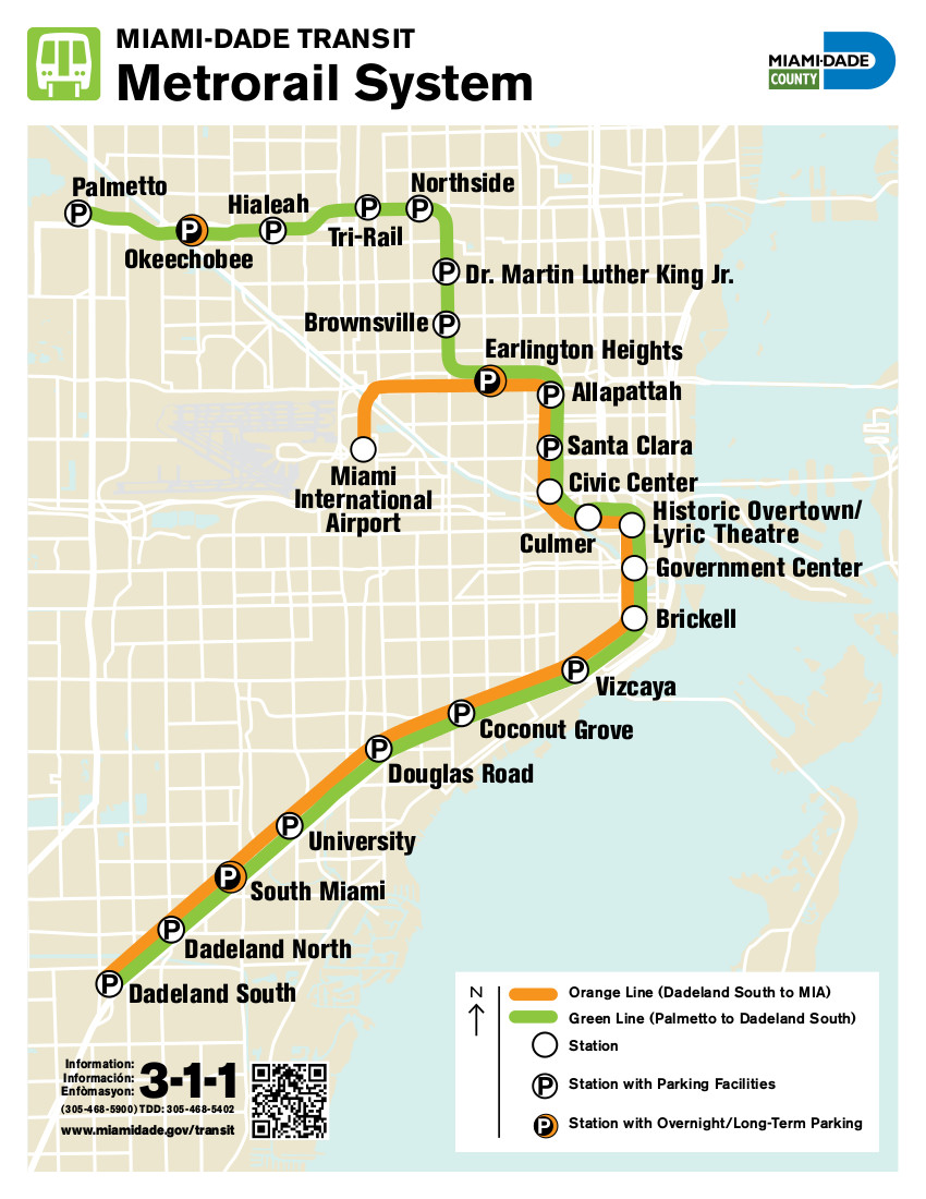
With a total of 39,2 kilometers, the Metrorail lends its service from Medley village to north of Miami-Dade county, up until Kendall district on the south of the city. It's composed by two commercial lines, the Green and the Orange, together they add a total 23 stations. They both share the route on 15 stations, from Dadeland South Station terminal to Earlington Heights Station, where the Orange line detours towards the city's airport heading West, and the Green line keeps going North.
Stations
Dadeland South station: Its opening is set in may 20th , 1984. It's located in the intersection between Dadeland Boulevard and Datran Boulevard; about three blocks away from the Dadeland Mall. It's served by the Green line and the Orange line.
Dadeland North station: Inaugurated in may 20th 1984, it's located in the Dadeland area; specifically on the intersection between South Dixie Highway route and Southwest 83rd Street, two blocks away from Kendall Drive. Lines Green and Orange serve this stop.
South Miami station: founded on may 20th, 1984 in South Miami. It's located in the intersection between South Dixie Highway and Sunset Drive street, two block away from Red Road. Both subway routs operate in this station.
University station: Located in the neighborhood Coral Gables, south of Miami, at the Ponce de León boulevard, right between South Dixie Highway and Mariposa Court. It opened to the public on may 20th, 1984 and it serves both routes in the system.
Douglas Road station: Inaugurated on may 20th , 1984 and built southwest of Coconut Grove, between Douglas Road avenue and South Dixie Highway street, just three blocks away from Bird Road highway. Both Green and Orange lines serve this station.
Coconut Grove station: It lends service to Coconut Grove neighborhood habitants. It's located in Grapeland boulevard, between South Dixie Highway route and West 27th avenue. It began its operations in may 20th 1984 and it's served by the two Metrorail lines.
Vizcaya station: It's been running since may 20th 1984 on the neighborhood called The Roads. It's located between Southwest First avenue and 32nd Road street. Lines Orange and Green lend service at the stop.
Brickell station: Its opening was more recent, may 26th 1994. It serves the financial district at Brickell, on the center of Miami, being located between SW 1st avenue and SE 11th street. Routes Green and Orange lend service at the station.
Government Center station: Opened on may 20th 1984, it serves the Government Center district at the Miami Downtown. Located at the intersection between Northwest First stret and First avenue, it's tended by both lines of the system.
Historic Overtown/ Lyric Theatre station: Also at the center of the city, its opening goes back to May 20th 1984. Its located between Northwest Sixth street and First avenue, south of Overtown neighborhood. It's served by Green and Orange lines.
Culmer station: The station lends service to Spring Garden neighborhood habitants, its located between Northwest 11th street and Seventh avenue. It opened its doors on December 17th 1984, being served by both routes in the system.
Civic Center station: Inaugurated on December 17th 1984, it serves Heath district. It’s located between Northwest 12th avenue and 15th street, where routes Green and Orange operate.
Santa Clara station: It was founded on December 17th 1984, to tend to the residential neighborhood Allapattah. The station is located between Northwest 12th avenue and 20th street. Both Metrorail lines operate in it.
Allapattah station: As the one before, it serves the Allapattah neighborhood, where it was inaugurated on December 17th 1984. Both subway lines go through this stop, located between Northwest 12th avenue and 36th street.
Earlington Heights station: It was built on Brownsville neighborhood, lending service since july 2012. It's located on Northwest 21st avenue, in the intersection with Airport Expressway. It's the last station transited by both routes.
Miami Airport station: It's one of the most recent stations is the system, where not only does the subway operate but also many bus lines. It's located on West 37th avenue, near Northwest 21st street. It's only served by the Orange line, being at the same time, a terminl station. It has been running since July 28th 2012.
Brownsville station: It tends to the Brownsville neighborhood, in the intersection of Northwest 27th avenue and 52nd street. It's traveled only by the Green line. Its opening goes back to May 19th 1985.
Dr. Martin Luther King Jr. Plaza station: Open since May 19th 1985, it lends service to Gladeview neighborhood, between West 27th avenue and North 62nd street. It only counts with the service of the Green line.
Northside station: Located between Gladeview and West Little River neighborhoods, on Northwest 31st avenue and 79th street, it's served by the Green route. Opened in May 18th 1985.
Tri-Rail and Metrorail Transfer station: It tends to the Hialeah area, on East 25th street with 11th avenue. Trains on Green line lend service to this station, inaugurated on June 5th 1989.
Hialeah station: It also serves the Hialeah area, between East First avenue and 21st street, south of the Hialeah Park Race Track complex. In this line only the Green line operates and it was opened on May 19th 1985.
Okeechobee station: It's located on Medley, between Northwest 77th street and 79th avenue. It's the terminal station on the green line, it opened its doors on May 30th 2003.
Hours and connections
The Miami subway system lends its service from Monday to Sunday, setting its schedule this way:
From Monday to Thursday it operates from 5:00 am to 11:00 pm
On Fridays the system opens its doors at 5:00 am, operating uninterrupted until midnight.
When it comes to Saturdays, the service is available from 6:00 am until midnight.
On Sundays, it operates from 6:00 am until 11:00 pm
On the other hand, the Metrorail offers a connection to the Metrobus service (bus lines that tend to zones near the stations) in all its stops. However, it also connects to the Metromover and the Tri-Rail railroad. In the first case, it connects on the Brickell station trough a transfer to Brickell Loop route on the monorail. In Government station, the very center of town, it connects to the Inner Loop, Brickell Loop and Omni Loop lines of the Metromover. With the Tri-Rail it connects at the Tri-Rail and Metrorail station, it lends its service to border areas on the North of Mirth of Miami.

Rates
To use the Metrorail the user must get an EASY Card, this card's value is up to 2$, or an Easy Ticket pass. You can buy both options at the vending machines located in every station, authorized sale locals or at the Miami Transport Services Center. The ticket and the card have different sale modes, although the ticket is not rechargeable. The flat rate to travel on the subway is $2,25 but it counts with several attractive special rates that could work for frequent users. They're classified as follows:
- 1-Day Pass: It allows to travel for a full day on the system. Its price is $5,65 and it can be bught any day of the month.
- 7-Day Pass: It's valid for seven days from its first use, period in which, the user will be able to use the service without any limits. The price of the pass is $29,25.
- 1-Month Pass: It allows the passenger to enjoy of the service for a full month. However, the pass expires the last day of every month; which means, regardless of the date it's bought when the last day of the month arrives, the pass will expire. The pass can't be bought between days 11 and 20 of the month. Its price is $112,50.
- 1-Month + Parking: It's the same as the one metioned before but adding parking in every station, for the same amount of time. The price is $123,75.
- College EASY Ticket: Thanks to the full tiem college student discount program that the Metrorail offers, there's a College EASY Ticket. With it, students get a monthly 50% discount on the final rate. Which means, instead of paying the $ 112,50 corresponding to the final rate, the pay $56,25.
- K-12 EASY Card: It's about a program designed for highschool students, public or private, of the Miami-Dade county. To enjoy this benefit, students must make an online request, with their EASY Card previously registered in the system; after qualifiyng, they will get a 50% discount in every trip and payment plans that the company in charge of the Metrorail offers. Childs younger that 12 years don’t have to pay.
- Golden Passport EASY Card: Thanks to this pass, any resident of Miami-Dade county older that 65 years , can travel completely free in the subway system and Metrobus. It has a 20 year validity, with the option of renewal.
- Patriot Passport EASY Card: This program looks to give back to the retired soldiers that live in the Miami-Dade county, and suffer any kind of disability caused in combat. With the pass they can use the subway and Metrobus services completely free.
- STS EASY Card: With this special transport service, people with disabilities may ask for exclusive services, such as transport vehicles that moves them to their homes. In this case, every ride has a cost of $3,50, however the tour in the subway is free.
Regulations
- Passengers that travel in the system, must wear shoes and shirts at all times.
- Belongings or passenger limbs can't obstruct the way through the halls for other passengers of the trains.
- Given the case of blind people, they must communicate their destination stop to the subway personnel so that they can provide the necessary help.
- It's strictly forbidden to run through the station's platforms.
- If you wish to transport a bicycle in the Metrorail, you can do so, as long as you use the last wagon of every train.
- To use music players in the wagons, you must use headphones, in order to avoid generating disturbs in other users.
- It's not allowed to smoke in the Metrorail installations, both in trains and stations.
- The consumption of illegal substances on the subway facilities is strictly forbidden.
- Making graffities, cuts or damages to the subway installations is punished by the competent authorities.
- The transport of animals is allowed, as long as they're inside their respective cages or special containers for it.
- Handling any staff only equipment is considered illegal.
- Using emergency equipment when there are no emergencies, is fined.
- It's not allowed under any concept, interfering on the closing of the train doors.
- Wait until the train stops to come close.
- It is absolutely forbidden, to offend or assault other passengers in any way, physically or verbally.
- The handling of pyrotechnics inside the system's facilities is not allowed.
Airport Connections
The Miami subway offers a direct connection to the terminal of the Miami International Airport. To get there from the city's downtown, you just have to take the Orange line on the Metrorail heading north. After approximately 16 minutes of ride, the passenger will arrive at the final station, the Miami Airport station, which has a direct transfer to the airport.
In the same way, if the passenger wishes to travel downtown using the subway, he or she will only have to get a ticket in the dispensers located at the station to board the trains on the Orange line, these trains connect with the Green line and the Metromover. It's important to point out, that in the subway stop several Metrobus routes lend service, complementing the train's route.
Future Expansions
The Miami subway was designed with the intention of expanding its routes constantly. Some of the expansions proposed so far are the following:
Biscayne corridor/ Northeast: With 21,9 kms this route hopes to connect the center of town with the Aventura area.
East-West Corridor: With 27,7 km of tour, this route is meant to join downtown with the Miami Port, on East, and also with the Florida International University campus on West.
34 km extension of the Green line, South, tending to the Florida City area.
Kendall Corridor, which route is comprehended of 24 km, joining the Dadeland North station with West Kendall surroundings.
Currently city hall has the expanding of the Orange line as a priority, with planes of connecting all expansions by the year 2030 and depending of the federal budget available.
Tourism near the subway
Near Vizcaya station, you can find the Patricia and Phillip Frost Museum of Science, an important museum, planetary and aquarium in Miami city. It was formerly known as the Junior Museum of Miami, when it first opened in 1949. During its beginnings, the exhibitions consisted of items donated by local citizens and others given by the Florida University. Then, after being relocated, it was named Museum of Science and Natural History, in 1952. It was in 2015 when its name was modified for the last time, to the current. It's ideal for science and cosmos lovers.
On the other hand, in the Government Center station, users can approach the Miami History museum. A 70.000 square foot complex that holds more than a million historical images and thousands of XVII and XVIII century artefacts. It's considered as the history museum with the most relevance in the south of Florida. Amongst its permanent exhibitions the famous Tropical Dreams: A People's History of South Florida is included, which makes a historical tour of the towns that have occupied the Southern state of the American union; highlighting the transcending facts that made the territory what it is today. Including the first native settlements, the Spanish conquering periods, World War II, among other big events. It's an ideal place for history lovers, located in the very Downton of Miami. Plus, in the complex also take place different conferences, historic investigations publications along with help aid services for students that require the use of any of its copies.
Metro map of Miami
See map full resolution. It may take a little bit to load.
Miami Metrorail map
- Also Known As: Metrorail
- Passengers/Day 49300
- Fares: 1.66
- 24h operation: No
- Air Conditioning: Yes
- Walk between platforms: No
- Driverless trains: Downtown people mover, rubber-tyred (since 1986)
- Screen Doors Platforms: No
- Average Speed: 106km/h
- Operator: Miami-Dade Transit
- $2
- Miami Metro Official Website
Help us
If you consider that the information we provide is wrong, not accurated, outdated, translation contains errors, and you would like to help us to improve the file...you can contact us here.
Feel free to contact us if you dont find the system you're looking for and we'll add it as soon as we can!
Thank you very much!