


Sydney is a city with a developed transportation system. It has bus lines, ferries, suburban railway lines, and two metro lines under construction. The current suburban railway network, Sydney Trains, extensively connects the city, almost like a metro system.
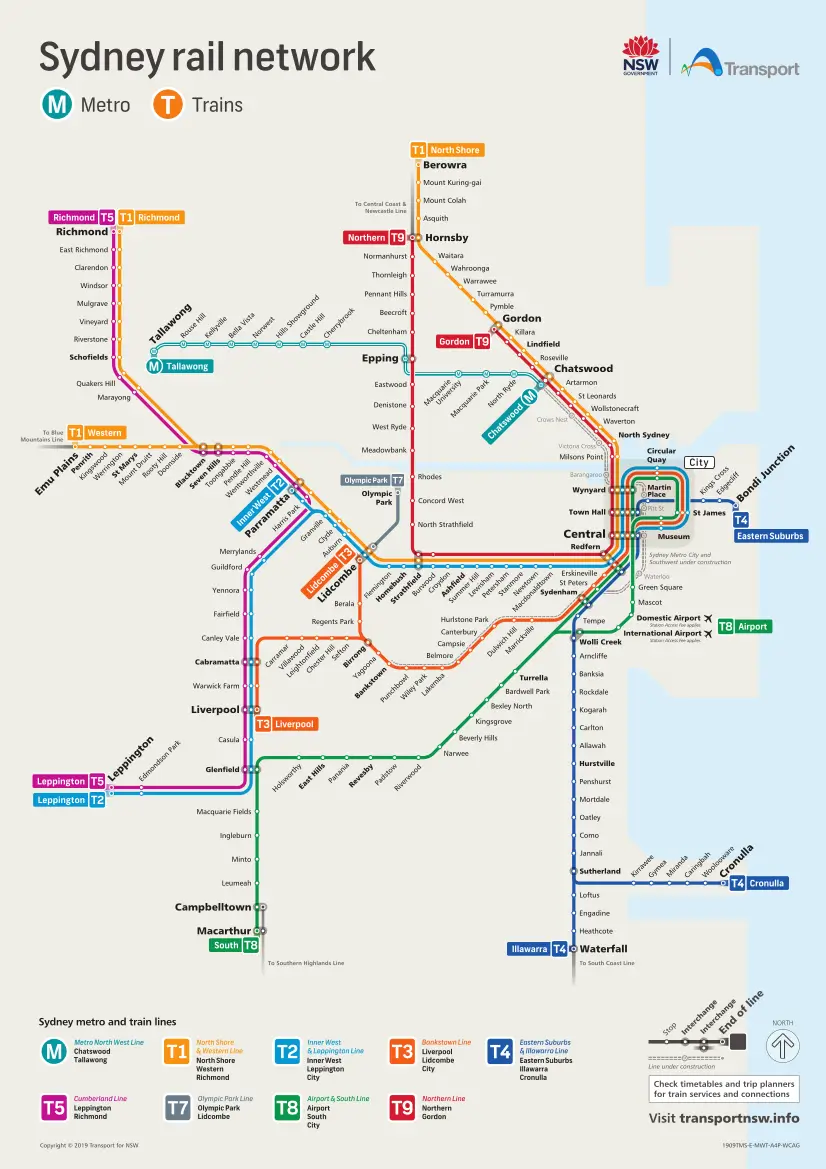
Sydney Trains has 170 stations, 815 kilometers of railway tracks with 368Kms of routes and 8 lines. Each line has its schedule but in general, they operate from 4:00 a.m. to 1:00 a.m. The frequency is every 3-8 minutes. Payment is made through the Opal card, although you can also use your credit card. Sydney Trains serves the city's airport.
Sydney Metro
Sydney is the most populated and the most well-known city in Australia. Positioned as a metropolis, it is home to over 5 million people, which makes up about 20% of the country’s population.
Sydney is a flourishing city with very high-quality standards of living. It is additionally widely renowned for its reception of foreigners. Among the attractions for them is the search for an excellent education. Likewise, business, tourism, culture and sports, characteristic to Sydney, display it as a vibrant metropolis, filled with things to do.
Although the entrance to this city could pass as that of a major US city, and while it’s true that Australia and the US share very similar cultures, there are various elements that set Australia apart from the North American country. This includes its public transportation.
Sydney has a bus line, a suburban railroad line, and two metro lines under construction, the latter of which will begin to operate in 2019.
However, what actually came to be emphasized is the current suburban railroad line. Operating under the commercial name, Sydney Trains, it thoroughly connects the city, almost at the level of a metro system.
This company begin providing service in 2013, following various scandals with Sydney’s previous commuter train operators. It has a total of 178 stations, 815 kilometers (506 miles) of railroad and 8 lines; the description of a system that connects the entire metropolitan area of an urban conglomerate and its suburbs.
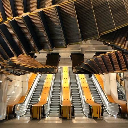 Wynyard Station
Meanwhile, work on the current Sydney Metro continues to be executed. With 66 kilometers (41 miles) of projected routes, the hope is that it will be finalized in the beginning of 2019.
Still, the present Sydney Trains system will expound on its current characteristics, in view of what can be accomplished in relation to urban transportation demands.
Lines and statiosn
The current Sydney Trains railroad is 815 kilometers (506 miles) and there are 178 stations connecting Sidney’s urban and suburban areas. At the end of 2017, the system transported about 340 million riders, clearly outlining the importance of this service for Sydney residents.
Likewise, it has 8 commercial routes that are entrusted with connecting the city’s surrounding neighborhoods and other neighborhoods with its city center.
(T1/T9) North Shore Line, Northern & Western
The first route on Sydney Trains can be identified on system maps by the color yellow, in addition to the number T1. It serves the city’s northern and western neighborhoods, among which the communities of Blacktown and Perinth, Chatswood, Parramatta, Hornsby and the Central Business District stand out.
As this is not so much a metro system, the railroad lines do not have the exclusivity of being served by just one line and trains travel to many stations.
(T2) Inner West & Leppington Line
This line can be identified on system maps by its light blue color and the designation T2. It provides service to the western and southwestern areas of Sydney as well as to the city center. It serves the Central Business sectors in the heart of the city and the neighborhoods of Haymarket, Ashfield, Granville, Parramatta, Warwick Farm and Glenfield, among others.
In total, this line serves 37 stations, many of which are interconnected to other lines on Sydney Trains.
(T3) Bankstown Line
This line is easily identifiable on system maps by its characteristic color orange and the number T3. It serves the suburban area of Canterbury-Bankstown, the Inner West area and the Western Sydney region.
 Martin Place railway station
It runs from part of the Central Business district and later passes through the neighborhoods of Sydenham, Dulwich Hill, Bankstown, Berala, Carramar and Liverpool, as well as others. In total, there are 33 stops on this train route, many of which connect with other lines within the system.
(T4) Eastern Suburbs & Illawarra Line
This is one of the system’s oldest lines. Its construction dates back to 1880 and it serves Sydney’s eastern and southern suburbs. It is easily identifiable on train maps, characterized by its azure blue color and the number T4.
It has 33 stops with one branching off at Sutherland station, in which some trains divert to neighborhoods such as Kirrawee, Caringbah and Cronulla, in the south of the city; while others likewise branch off, but towards suburbs in the southeast of Sydney; such as Engadine, Heathcote and Waterfall.
(T5) Cumberland Line
This route serves residents in Sydney’s western communities. It is represented on maps by the number T5 and the color magenta. Included among the neighborhoods it serves are Richmond, Mulgrave, Toongabbie, Guildford, Casula, and the bordering communities.
It has 23 stops and each station was constructed with a specific community in mind, creating a circular line that runs through 23 distinct western suburbs of Sydney.
(T6) Carlingford Line
Having just 7 commercial stops and despite its old age, with a railroad route inauguration in 1888, it is the smallest line on the Sydney Trains.
Running north to south through the city, it travels through suburbs such as Rosehill, Camellia, Dundas and Telopea. It is easily identifiable on railway maps, characterized by the color purple and the number T6. This route is so short that a trip from one side to the other only lasts 12 minutes.
(T7) Olympic Park Line
This route was exclusively created to connect residents with the Olympic village structures from 2000, when Sydney hosted the Olympic Games. Presently, it is completely unused, with a route of just 7 kilometers (4.3 miles) and only one station destination.
It can be identified on maps by the color gray and the number T7.
(T8) Airport & South Line
This system route is the newest and is responsible for connecting residents of Sydney’s southwestern neighborhoods to the city center. It is quickly recognizable among riders, by the number T8 and the color green.
It has a total of 32 stops with a station dedicated to the airport. It stands out as one of the only routes on the Sydney Trains that reaches the terminal. It also serves the neighborhoods of Beverly Hills, Glenfield, Padstow, and Bexley North as well as the southern area of the city.
Sydney Metro Map

Connections
The Sydney Trains stations are extremely interconnected with complementary bus routes, as well as with the various lines that operate on its routes. The above mentioned stations include the following connections:
T1 Line
- Wynyard Station: T2, T3 and T8.
- Town Hall Station: T2, T3, T4 and T8.
- Central Station: T2, T3, T4 and T8; also connects with the light rail train station.
- Redfern Station: T2, T3, T4 and T8 (the last only during peak hours).
- Burwood Station and Strathfield Station: T2.
- Lidcombe Station: T2 and T3.
- Auburn Station: T2.
- Clyde Station: T2 and T6.
- Granville Station: T2.
- Harris Park Station and Parramatta Station: T2 and T5.
Westmead, Wentworthville, Pendle Hill, Toongabbie, Seven Hills, Blacktown, Marayong, Quakers Hill and Schofields stations connect with the trains on the T5 line.
T2 Line
- Museum Station: T3 and T8.
- St. James Station: T3 and T8.
- Circular Quay Station: T3 and T8.
- Wynyard Station: T1, T3 and T8.
- Town Hall Station: T1, T3, T4 and T8.
- Central Station: T1, T3, T4 and T8; also connects with the light rail line.
- Redfern Station: T1, T3, T4 and T8.
- Burwood Station and Strathfield Station: T1.
- Lidcombe Station: T1 and T3.
- Auburn Station: T1.
- Clyde Station: T1 and T6.
- Granville Station: T1.
- Harris Park Station and Parramatta Station: T1 and T5.
- Cabramatta Station, Warwick Farm Station and Liverpool Station: T3 and T5.
- Glenfield Station: T5 and T8.
Merrylands, Guildford, Yennora, Fairfield, Canley Vale, Casula, Edmondson Park and Leppington stations are only connected to the T5 line.
T3 Line
- Town Hall Station: T1, T2, T4 and T8.
- Wynyard Station: T1, T2 and T8.
- Circular Quay Station: T2 and T8.
- St. James Station: T2 and T8.
- Museum Station: T2 and T8.
- Central Station: T1, T2, T4 and T8. (It also connects with a light rail route.)
- Redfern Station: T1, T2, T4 and T8 (the last only during peak hours).
- St. Peters Station: T8 (only during peak hours).
- Sydenham Station: T4 and T8 (only during peak hours).
- Lidcombe Station: T1 and T2.
- Cabramatta Station, Warwick Farm Station and Liverpool Station: T2 and T5.
T4 Line
- Town Hall Station: T1, T2, T3 and T8.
- Central Station (underground): T1, T2, T3 and T8.
- Redfern Station (underground): T1, T2, T3 and T8.
- Sydenham Station: T3 and T8 (only during peak hours).
- Wolli Creek Station: T8.
 SMC Conference u0026 Function Centre
T5 Line
- Parramatta Station: T1 and T2.
- Harris Park Station: T1 and T2.
- Cabramatta Station: T2 and T3.
- Warwick Farm Station: T2 and T3.
- Liverpool Station: T2 and T3.
- Glenfield Station: T2 and T8.
Schofields, Quakers Hill, Marayong, Blacktown, Seven Hills, Toongabbie, Pendle Hill, Wentworthville and Westmead stations have connections to the T1 line. Merrylands, Guildford, Yennora, Fairfield, Canley Vale, Casula, Edmondson Park and Leppington stations also service trains on the T2 route.
T6 Line
- Clyde Station: T1 and T2.
T8 Line
- Town Hall Station: T1, T2, T3 and T4.
- Wynyard Station: T1, T2 and T3.
- Circular Quay Station: T2 and T3.
- St. James Station: T2 and T3.
- Museum Station: T2 and T3.
- Central Station: T1, T2, T3 and T4.
- Redfern Station (only during peak hours): T1, T2, T3 and T4.
- St. Peters Station (only during peak hours): T3.
- Sydenham Station (only during peak hours): T3 and T4.
- Wolli Creek Station: T4.
- Glenfield Station: T2 and T5.
Schedules
The various schedules for each of the Sydney Trains routes and the number of trains running throughout the day are available on the official web page. Nonetheless, operating hours begin at 4:00 am and typically end at 1:00 am.
However, there are trains that operate later and likewise there are trains that leave earlier. In any case, the exact hours are published online.
Train frequency varies depending on the station hours. Trains service the platforms every 6-8 minutes during normal hours, and it is reduced to just 3-5 minutes during peak hours.
Fares
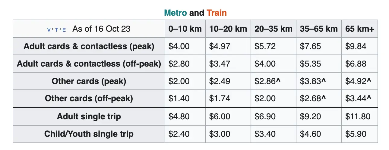
Since 2014, the payment method for the Sydney train system has been a reloadable Opal card. The fee structure is based on the number of kilometers (miles) of a passenger’s trip, more specifically it is a calculation of the distance the rider travels.
The Opal card is valid for the entire Transport NSW network (ferry, bus, train, and light rail services). The user swipes the card at the beginning and at the end of the journey. The system then calculates the price of the trip and deducts it directly from the available balance on the card. Payment can also be made with Visa or Mastercard, but the prices per trip may be higher.
Additionally, there are various types of Opal cards, focused on different types of riders. The latest are detailed below.
Adult Opal Card: As the standard payment method, this is the system’s main card. It is geared towards riders over the age of 16 who wish to travel on Sydney Trains.
Child/Youth Opal Card: This option is for children and youth, aged 4-15 – although full time students, aged 16 can also select this card.
Gold Senior/Pensioner Opal Card: This method was especially designed for the elderly, meaning those senior citizens over the age of 65.
Concession Opal Card: This method benefits participants who are a part of the institutions registered under concession programs. The list of programs can be found on the web page opal.com.au.
Opal single trip tickets: Lastly, are Opal single trip tickets. These traditional tickets can be obtained from ticket machine dispensers found in the system’s stations. Though they can only be used once, the price, similar to the fare cards, is based on the distance the passenger travels.
- With the exception of guide dogs and police dogs, Sydney’s train system strictly prohibits transporting animals.
- Transporting open bottles and the consumption of alcohol on trains and in stations is prohibited.
- People found to be in an inebriated state or those demonstrating violent or inappropriate behavior in Sydney Trains facilities will be removed.
- All toxic substances, flammable materials and potentially dangerous objects are prohibited on stations and trains.
- No rider is permitted to transport supermarket carts within train facilities.
- Smoking, including electronic cigarettes, is prohibited in any metro facility.
- Bicycles are permitted on the train at any time. However, they should not obstruct the free movement of passengers throughout the facilities.
- For their comfort, people with limited mobility will find reserved spaces in stations and on trains. These riders shall not have their movement restricted due to other groups occupying the spaces that have been reserved for them.
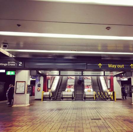
- Try to keep to the left side on escalators, permitting other riders with greater urgency to proceed on the right.
- Placing feet on train seats is prohibited.
- Avoid getting on or off the train after the announcement of doors closing.
- Don’t occupy the seats that are reserved for elderly people, people with disabilities or pregnant women.
 Fares
Fares
View updated fares here.
Sydney Metro
The Sydney Metro is a fully automated rapid transit system that has been in operation since May 26, 2019, with the inauguration of the Metro North West Line. Currently, extensions are being carried out and new lines are being developed as part of an ambitious expansion project. One of these extensions is the City & Southwest project, aiming to connect Chatswood with Bankstown by 2024.
By 2030, the Sydney Metro is expected to have 113 kilometers of new metro tracks and 46 stations in total. Among the significant projects under development are the Sydney Metro West and the Western Sydney Airport project. The former aims to connect Westmead with Sydney's CBD, while the latter plans to connect St Marys with the new Aerotropolis station in Badgerys Creek, serving the new Western Sydney International Airport scheduled to open in 2026. However, the Metro West project has faced financial challenges, with high construction costs.
The Sydney Metro stands as the largest public transportation project in Australia, seeking to provide fast, safe, and reliable transportation to the city. The modern and fully accessible trains are designed to operate without a fixed schedule, allowing passengers to simply arrive and board, thus facilitating efficient and convenient transportation.
Its profile on Mapa-Metro.com will be available soon.
Regulations
Connection to the airport
The Sydney airport, officially called the Kingsford Smith International Airport, has a metro station in each of its two terminals (national and international), with the purpose of connecting visitors with the city center and the surrounding suburbs.
The Sydney Trains system is extremely advantageous, if wishing to travel to the airport without having to rely on taxi service. To reach the airport, one must take Line 8 (T8) from one of its pick-up points and get off at International Airport Station when taking an international flight. If taking a national flight, remain on the national level until reaching the Domestic Airport Station destination. In either case, the terminal area can be found on the ground level at these stops.
However, there are many different options if the goal is to reach Sidney’s town center after arriving at the airport. There are car rental services, taxi stands, bus routes, and even a limousine rental service. Located right below the airport, the train station is the most economical and efficient option. From there, one can reach the city center as well as the surrounding neighborhoods.
Future projects
The main project to stand out is the Sydney Metro itself. Although Sydney Trains have the characteristics of a metro system, they are still just a collection of commuter trains. Consequently, the Sydney Metro will begin to function as early as 2019 with the inauguration of Line 1 as one of two planned lines.
According to available information, it will be 66 kilometers (41 miles) with 31 stations. In its first stage it will connect Rouse Hill neighborhood with the suburb of Chatswood and pass through the business district (CBD). An expansion is foreseen as well. It will complement two construction routes that are to be built in 2024.
Tourist sites
Sydney is a multifaceted city, among which a mixture of art and trendy styles can be found. One of the most iconic symbols, of any location, is the emblematic Sydney Opera House. It is located just meters from Circular Quay Station which is serviced by the T2, T3, and T8 lines
With its relevance as a World Heritage Site since 2007, this is a must see stop for those visiting the city. Visitors can enjoy musical performances, ballet, symphonic concerts, operas, and plays; in addition to the New Year’s Eve celebrations. The lights and fireworks fuse with the structure, giving it the appearance of a portrait beyond compare.
A few meters from this famous opera house is the equally well-known Sydney Harbour Bridge which can also be reached from Circular Quay Station. The structure merits a visit for its architecture, history and significance to the city. At night, the lights that caress the structure make it a memorable image that is well worth a social media post or just treasuring it among the memories of an unforgettable trip.
Metro map of Sydney
See map full resolution. It may take a little bit to load.
Download map.
Sydney Cityrail map
- Also Known As: Cityrail
- Passengers/Day
- Fares:
- 24h operation: No
- Air Conditioning: Yes
- Walk between platforms: No
- Driverless trains: No
- Screen Doors Platforms: No
- Operator: Transport for NSW
- $4.80
- Sydney Metro Official Website
- Tlf: 131 500


Help us
If you consider that the information we provide is wrong, not accurated, outdated, translation contains errors, and you would like to help us to improve the file...you can contact us here.
Feel free to contact us if you dont find the system you're looking for and we'll add it as soon as we can!
Thank you very much!